Geological Hazards
Volcanoes
Meteorological Hazards
Biological and Technological Hazards
Home

Contact the
webmaster.

|
Activity # 1: Volcanoes of Canada Natural Resources Canada maintains a database of all known volcanoes in Canada. The following activity will help you become more familiar with the types of Canadian volcanoes.
1. Go to the Map of Canadian Volcanoes site. 2. Pick a volcanic belt that falls mostly within Canada (either in British Columbia or the Yukon). 3. Select a volcanic area of interest. Continue selecting volcano groups until you reach the map with isolated volcanoes. 4. Select an individual volcano of interest and read the provided information.
Activity # 2: Mapping Mudflows of Mount Rainier
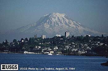
Fig. V-16 is a photograph of Mt. Rainier taken from the USGS web site. Mt. Rainier is located in Washington State. During its history, several lahars have been triggered by volcanic activity. These lahars are produced when hot material erupted from the volcano lands on and melts the ice and snow, producing rapidly moving mud and debris flows. Melting of snow and ice around steam vents may also produce lahars. Click here to see a table summarizing volcanic activity at Mt. Rainier.
Next, visit this web site to read more about landslides and lahars at Mt. Rainier. Scroll down to the bottom of the page and examine the map labeled "Extent of two Holocene Mudflows from Mount Rainier". Answer the following questions: 1. According to the map, what is the relationship of the mudflow occurrences to the major river drainages in the area? a. The mudflows mostly parallel major rivers in the area. b. The mudflow locations are independent of any rivers in the area.
Approximately how many kilometres did the Electron Mudflow travel? a. 5 km b. 15 km c. 50 km d. 150 km e. 500 km
Approximately how many kilometres did the Osceola Mudflow travel? Approximate your answer by measuring from Rainier northwest to near the city of Kent. a. 20 km b. 50 km c. 70 km d. 100 km e. 150 km
Finally, go to this web site.
Determine whether the mudflows were associated with significant volcanic activity by following these steps: 1. Click on the Western United States on the map. 2. Scroll down the page and click on USA-Washington. 3. Scroll down the page and click on Rainier. 4. Click on "Eruptive History" button. 5. Click on "Eruptive History (expanded)" button 6. Scroll down the page and determine if any significant eruptive activity was associated with the Electron and Osceola mudflows.
Mount Rainier is located near several communities, and, if you'll note from the map, some of these communities are situated in the pathways of major mudflows, and are susceptible to other volcanic hazards. Much careful planning must be undertaken to prevent significant harm to these communities.
Activity # 3: Monitoring Mount St. Helens
Read the information presented on the site. Then, write a brief essay summarizing the warning signs that told scientists that an eruption of Mount St. Helens was imminent in the spring of 1980.
Activity #4: Kilauea Eruption Visit this web site to learn about the 1960 Kapoho Eruption of Kilauea Volcano on the island of Hawai'i.
Read the information presented on the site. Then, write a brief essay outlining
what type of eruption this was, the progress of the eruption, the damage
that it caused, and the attempts made to mitigate the effects of the eruption.
|