Geological Hazards
Earthquakes
Meteorological Hazards
Biological and Technological Hazards
Home

Contact the
webmaster.

|
What is an earthquake?
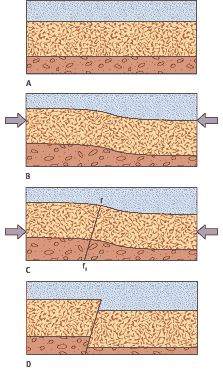
The figure here (from Unit 35 of Physical Geography) demonstrates how earthquakes happen. When rock strata (A) are subjected to stress, they begin to deform or bend (B). All rocks have a certain rupture strength, which means that they will continue to bend, rather than break, as long as the stress imposed on them does not exceed this rupture strength. When the stress finally becomes too great, the rocks suddenly move along a plane (the fault (C)) that may or may not have existed before the deformation began. That sudden movement snaps the rocks on each side of the fault back into their original shape (D) and produces an earthquake. An earthquake, then, is the release of energy that has been slowly built up during the stress of increasing deformation of rocks. This energy release takes the form of seismic waves that radiate in all directions from the place of movement.
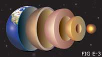
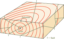
Earthquakes can originate at or near the surface of the Earth, deep inside the crust, or even in the upper mantle (see figure E-3 for a depiction of the Earth's layers.) The place of origin is the focus, and the point directly above the focus on the Earth's surface is the epicenter. The drawing below illustrates these concepts.
Faults It is important to note that there are different types of faults: Normal faults occur where the crust is being pulled apart or extended. The hanging wall or the overlying block moves downward.
Reverse faults occur where the crust is being compressed or pushed together. The hanging wall or the overlying block moves upward.
Strike slip faults occur where the pieces of crust slide past each other; in these faults, vertical motion is minimal.
To learn more about the various types of faults, and to see animations of faults in motion, visit this site.
The focal depth is the depth from the earth's crust to the focus.
Shallow earthquakes occur at depths between 0 and 70 km. Intermediate earthquakes occur at depths between 70 and 300 km. Deep earthquakes occur at depths greater than 300 km.
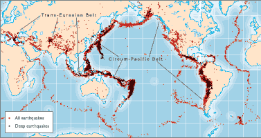
Where do earthquakes occur?
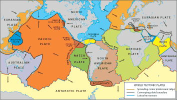
When we compare figures E-5 and E-6, it becomes clear that earthquakes take place most commonly along the earth's lithospheric plate boundaries (See Unit 32 of your textbook for more information on the lithospheric plates). Earthquakes take place along three types of plate boundaries: convergent, divergent and transform plate boundaries.
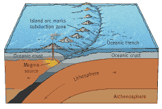
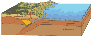
Convergent boundaries occur where two plates come together or converge. Associated with convergent boundaries are subduction zones, where one plate dives (subducts) beneath another toward the deeper interior regions of the earth. Shallow to deep earthquakes are associated with this type of plate boundary. (See Figures E-7 and E-8 for diagrams of convergent boundaries.)
Divergent boundaries occur in areas where molten materials rise, usually along extensive underwater mountain chains known as ridges and rises. The rising material results in the production of new crustal material. Shallow earthquakes occur along these boundaries.
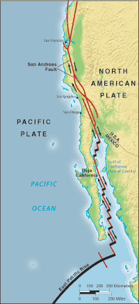
Transform boundaries occur where plates slide past one another. The classic example of this type of boundary is the San Andreas Fault (See Figure E-10), which marks the boundary between the southward moving North American Plate and the northward moving Pacific Plate. Transform boundaries are marked by mostly shallow earthquakes.
The greatest concentration of earthquakes is along the Circum-Pacific belt of subduction zones associated with the Pacific and Nazca Plates and their neighbouring plates. Another zone of high earthquake incidence is the Trans-Eurasian belt, which extends generally eastward from the Mediterranean Sea through Southwest Asia and the Himalayas into Southeast Asia, where it meets the Circum-Pacific Belt. And a third zone of earthquakes is associated with the global system of mid-oceanic ridges (See Figure 35.5 in your textbook). The earthquakes there are generally less frequent and less severe than in the Circum-Pacific belt. In Figure E-5 we can also see that some earthquakes do occur inside plates, rather than along plate boundaries. Note the scattered pattern of epicenters in interior Asia, in eastern Africa, and in North America east of the west-coast subduction zone. The causes of these intraplate earthquakes are still not well understood, but they can produce severe damage because people in the affected areas are generally less well prepared for earthquakes. In January of 2001, for example, an intraplate earthquake struck parts of India's Gujarat State. This earthquake became known as the "Bhuj earthquake" after the town nearest to the epicenter. As many as 20,000 people were killed in the earthquake, and entire towns were obliterated.
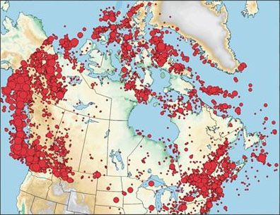
British Columbia lies north of California, but is still on the boundary between the Pacific and North American plates. This causes many earthquakes for the residents of BC. Take a look at the map below to see an illustration of Canadian earthquakes.
Measuring Earthquakes There are three methods used to measure the size of an earthquake.
1. Richter Magnitude. The first method measures the magnitude of an earthquake, and was originally developed in 1935 by Charles Richter, at the California Institute of Technology. Richter found a way to measure the magnitude of an earthquake using a logarithm of the amplitude of waves recorded by seismographs. The magnitude determined using this method is called the Richter magnitude, and the scale to which the magnitude is tied is termed the Richter scale.
On the Richter scale, magnitude is measured in whole numbers and decimal fractions. For example, a moderate earthquake might have a Richter magnitude of 5.3. The chart below shows that the energy released by an earthquake increases about thirty times with each increase in magnitude. The amount of ground motion increases ten times with each consecutive increase in magnitude.
Richter Scale and Associated Energy Release (data from US Geological Survey)
To learn more about how to determine Richter magnitudes, please visit this site.
2. Moment Magnitude. This method of measuring earthquakes measures the estimated amount of energy. Factors used to calculate the moment magnitude include the amount of slip on the fault, the type of rock in which the fault developed, and the area covered by the fault break.
3. Mercalli Scale. The intensity of earthquake damage is determined using the Mercalli Intensity Scale, which is based on the damage to structures at particular locations. Factors influencing earthquake intensity include: distance from epicenter, focal depth, duration of shaking, geologic material on which structures are constructed, the design of buildings, and, of course, the magnitude of the earthquake.
The following chart shows what the different Mercalli intensities mean, and also compares Mercalli intensities with Richter magnitudes.
Modified Mercalli Scale and Comparison with Magnitude (Data from US Geological Survey)
|